Day 13 (mile 180 – 180)
Today was a zero day – a day of no hiking. In fact we decided to take today and tomorrow off since Idyllwild seemed like a cool town to spend some time in.

The first order of business was to have some coffee which I hadn’t had for 2 weeks. Let’s throw in a cinnamon roll too, why not? I needed the calories.

I didn’t do much today except walk around the town and do a few town chores – do laundry, buy some replacement gear, eat copious amounts of food. And yes, I consider that last one a chore even though I love eating. Part of my strategy is to eat so much in town that to make up for all the calories that I’m not getting on trail.
Regardless, the day was fairly uneventful except for meeting back up with Rocksie and Perrie who we hadn’t seen for a few days. But an uneventful day is sometimes just what you need. Oh yeah and I also picked up a sweet Hawaiian shirt for $3 at a thrift store which you’ll get to see in a little bit.
Day 14 (mile 180 – 180)
Yet another zero day. We felt a little bad taking two zeroes already but our pace was so good and we weren’t in a hurry to get to the Sierras due to the high snow levels. We were on track to get there way before it was safe to enter so taking some time off only put pressure on our wallets.
To save some money, I split a 3 bedroom cabin with 5 other hikers instead of getting my own place. I’d been encountering this group on and off since the start – their names for future reference are: Loki, Savage, Kim, Austin, Spotlight. I’ll try to get a group picture at some point in the future if I’m still hiking near them.

One final chore I had to do before setting off the next day was resupplying my food. So here’s a really exciting picture of me doing just that. Don’t worry, I got some healthier stuff too.

There’s not much else to write about these zero days to be honest. I mainly just took it easy, let my muscles and joints recovered, and made sure I had everything ready to go for the next stretch. Of course it wouldn’t be a zero day without sitting around having beers with the other hikers, commiserating over shared struggles. This was one of the best parts of town. I definitely enjoyed taking time off, even if part of me felt guilty for not hiking. I think it’s easy to think of the PCT as just a wilderness trail but there are so many cool little towns and bits of culture you would never experience if you just stuck to the trail.
Day 15 (mile 180 – 186)
I know what you’re thinking, only 6 miles today? After 2 days of not hiking surely you can do better than that Adam.
Well today 6 miles was all I could do since we summited our first major peak, Mt. San Jacinto! The climb to the top was 4500 feet of straight elevation gain, mostly through snow as well. And this wasn’t even a part of the PCT. The official PCT went around the mountain but I decided that I would say ‘yes’ to more things on this journey so here I was climbing a mountain which I didn’t need to.

The first bit of the climb was easy, and by easy I mean there was no snow. We were still climbing and working hard. But the views were incredible. Eventually we had to take a break for water and to catch our collective breaths since the altitude was starting to become noticeable.

And just like that we hit our first serious snow on the climb up the mountain. This snow was serious business too, special tools were needed. Thankfully we all had microspikes – basically just snow chains for your shoes. See here.

With these we could dig into the snow and ice and ensure we wouldn’t slide down the side of the mountain. If you’re wondering what the colorful things over the tops of my shoes are, they’re called gaiters. They just keep rocks, twigs, dust, and other debris out of your shoes so you can hike uninterrupted. Anyways, below is why we needed the spikes. Things got steep and sketchy.

It’s hard to convey in a picture how steep the trail got but at one point we were just kicking steps straight up the mountain in snow.


As we neared the summit, we came across the emergency hut we had heard a lot about. We’d originally planned on staying the night there but we had plenty of time left in the day and there was already a crowd outside.

So we pressed on to the summit and boy was it worth it. You could see everything for miles and miles around because there’s basically nothing but desert surrounding San Jacinto (save for a few far off mountains which we’d be passing through soon). Oh yeah, here’s that Hawaiian shirt I picked up back in town. I think it made for a great summit photo. Plus it was actually a great shirt to hike in.

Everyone who summited decided to have lunch at the very top since we got there much earlier in the day than we expected. It was here that I sadly lost my knife cutting off a piece of cheese.

With plenty of time left in the day we all hiked as far back down the mountain as we could, eager to camp as close to Fuller Ridge as possible. Fuller Ridge is the one section of SoCal PCT that is infamous for being particularly sketchy and dangerous in high snow years so we wanted to hit it when the snow was solid in the morning.
Coming down the mountain was just as tough going up because the snow was slushy. We were slipping and sliding all over the place, plus there was a lot of postholing. Postholing, in regards to snow travel, just means taking a step expected there to be solid snow but in fact sinking up to your ankle/knee/mid-thigh sometimes. Not only is is super annoying but it’s also dangerous if you aren’t able to land correctly. Here’s an idea of how deep the snow was. On normal years that outhouse would probably have been accessible. Sadly, when I needed it now, it wasn’t.

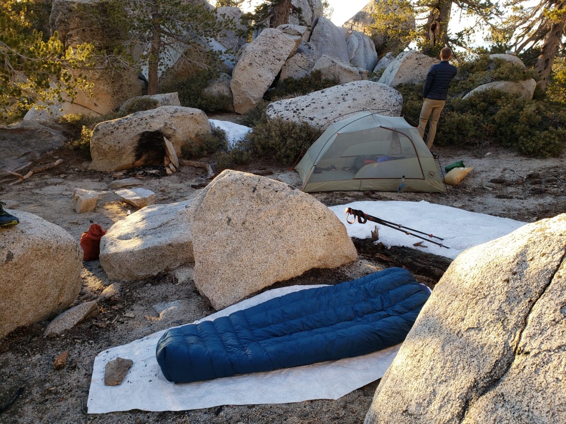
Shortly after we found a nice little campsite tucked away down off the trail about a hundred feet or so. I decided to cowboy camp even though it looked like it might freeze. Looking up at the stars made it worth it. Plus you can’t beat that sunset.
Day 16 (mile 186 – 201)
Probably the coldest night yet, I woke up and my socks were frozen in the position I left them to dry.

But we got to Fuller Ridge fairly early in the morning and besides being annoying to hike, it really wasn’t that scketchy or dangerous. The trail was just tough to follow at times and sometimes crossed steep sections. Nothing we hadn’t seen before.

After Fuller Ridge, the mountain was pretty much snow free so we were able to pick up our pace and actually make some decent mileage. As usual, the views coming down the mountain were stunning the whole way. We could see off in the distance the snow capped peaks we’d be passing through in the coming weeks.

All day we were just walking down off the mountain. Every foot we walked up we now had to walk down – from 10,800 at the summit to 3000 feet at the desert floor below. Most of us agreed that going downhill was just as difficult as going uphill, but in it’s own unique way. Downhill was hard on the joints, uphill hard on the muscles. You could really start to feel the “crest” in the Pacific Crest Trail. Little did we know we were just building up speed for the big uphill section of the rollercoaster in a few short days.

As we neared the campsite we were given some stellar views of the mountain we had been on top of just days before.

Unfortunately our campsite was super windy but it was the only flat area around for miles. I decided I didn’t want to set my tent up in the wind so I just cowboy camped and drew my quilt around me tightly so it wouldn’t flap around. Unfortunately the night was very warm so I got hot quickly in my 20 degree rated quilt. So when I opened it to get some air flow it just started flapping around again. I struggled with this all night and barely got any sleep. But it was a beautiful night and campsite.

Day 17 (mile 201 – 220)
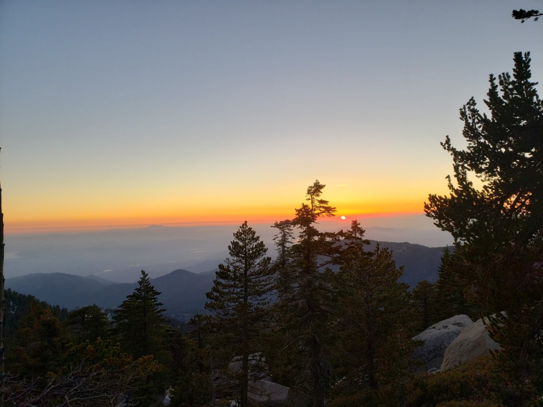
Today was the day we would finally get off the mountain and leave San Jacinto behind us. It seemed like this mountain took us an eternity to conquer but it was really only a few days. Maybe it’s just because it was our first real mountain. Anyways, the sunrise as we departed town was truly magical.

The descent to the bottom was hot and exposed, even though it was still the early morning. We were all glad to make it tk the bottom where there was a single water faucet to fill up our empty bottles. Ahead of us we had a difficult dry section and we needed all the water we could carry. It started with a road walk down to the desert floor. I couldn’t stop looking back at the mountain.

After the road walk we had an insanely windy 4 mile walk through a dry, sandy wash. This was a surprisingly difficult stretch because each step took so much more effort with the wind blowing directly at you and the sand taking the energy out of every step. As always, it was beautiful though.


After trudging through the sand we made it to a little beacon of civilization, the I10 underpass. And there was trail magic! Two former thru hikers set up a spread of fresh fruit, cookies, chips and salsa, beer, and soda for us weary novices. It was just what we needed at the time, thanks y’all!


We probably stayed longer than we should have just enjoying the shade and refreshments. It was completely worth it. But we had to keep going about 10 more miles to get to our next water source – the first actual perennial river on trail, Whitewater. We’d heard it was flowing strong this year because of all the rain and snow.
So we hiked through miles of heat and desert. And it was hot. Maybe I had just gotten used to the cool mountain air but the desert today was brutal. Somehow it was humid in the desert, thanks to the cloud cover I guess. So at least the sun wasn’t too bad.


After we created some of the desert hills we entered a new environment, the foothills and canyons of the San Bernadino mountains. And where it had been hot and miserable just minutes earlier, now it looked like it might rain and a cool wind kicked in. The weather on the PCT can change in minutes, quite literally. Don’t let anyone tell you SoCal is just sunny and 70 all the time.
I got a glimpse of the river valley soon and it was very impressive. Just and tiny little river had seemed to carve out this massive canyon.

I descended down into the valley and came to the river which was flowing strong. But it was still dwarfed by the landscape it had formed over the years.

It was nice to have cool, clean running water to soak our feet and clean up in. Plus the clouds had begun to part and it looked like we’d have a nice evening.
Day 18 (mile 220 – 239)
I’m glad I set up my tent because we got a decent bout of rain that night. Even some lightning and thunder! But it subsided and the morning was clear. Unfortunately we had to cross the icy snow-melt river first thing in the morning which was a bit of a shock to the system.

Then, when we stopped to have breakfat, my phone started acting strange and the screen would just go black after turning it on. Which wasn’t good, because I relied on my phone for water and general trail information and pictures. So this day doesn’t have many, only those which Salsa was able to take. I was obviously pretty stressed out because of my phone and we were 50 miles from the next town, Big Bear which didn’t have a Sprint store or cell phone repair place. Ah well, I’d just have to hike on and figure it out later.

Another windy, beautiful day. Although today we had to climb 6000 feet over 20 miles which I don’t think we quite understand the gravity of starting out. The main climb just followed a creek pretty much all the way up to the source in the mountains, 6000 feet up. In fact, our campsite would be the spring itself. So we started the climb which was thankfully super gradual. The PCT generally takes you up mountains very gently, sometimes without realizing you’re going up at all. However much of the trail had been destroyed in floods early this year so we had to do a lot of bushwacking and route finding around the flooded sections.

The creek and surrounding greenery were a pleasant break from the surrounding desert. Most notably, there were all sorts of fragrant smells that I wish I could have identified but it was just a really pleasant section of trail for the senses. There was cottonwood, ash, willow, and maybe even some kind of bamboo.
The climb just kept going up and up until we noticed we were in the mountains and no longer on the desert floor. And with this change of environment came a rapid change of weather – as I’ve now come to accept as standard on the PCT. We had hiked so high that we entered a new microclimate and the temperature basically halved and the clouds literally enveloped us. This, in addition to hiking in a burned out forest, made for a spooky and quite chilly hike into camp. Unfortunately this is the last picture for the day since my phone only started working again later that evening.

Cold, damp, and exhausted, I just crawled into my tent and quilt at around 7:30 and passed out.
Day 19 (mile 239 – 262)
Thankfully my phone was working today so I woke up in a much better mood despite my tent and basically everything else being completely frozen. The sun had come out and we were starting late to let things thaw out. We only had about 1000 feet left to climb and in just a little while we saw our first trail snow since San Jacinto. I was surprised there wasn’t more since we were over 8000 feet T this point.

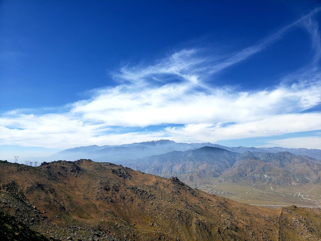
Off in the distance we could see the snow capped peak of San Gorgonio mountain, the highest peak in southern California. Thankfully we wouldn’t have to climb this one, just go around it.

And of course, one last look at San Jacinto way off in the distance. Had we really come so far so quickly?

This was a really easy, relaxing day of hiking and I loved every second of it. A good portion of the hike went through tall pine forests which is one of my favorite ecosystems.

Around lunchtime I figured it would be a great time to take a siesta under this really cool tree I found. Unfortunately the wind made it a little chilly but the view looking up was amazing.

To top a great day off, I met a school group out hiking the trail and they all wished me good luck on my way to Canada which boosted my spirits more than I could have expected. Our campsite that night was beautiful too, just barely overlooking the desert below.

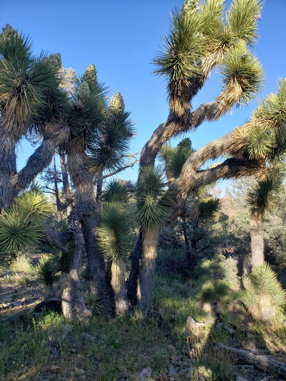
Also anyone know if these are Joshua trees? I saw a bunch of them along the trail but I wasn’t sure if they grew here.
All in all it was a great day of hiking and I did about 22 miles which is probably more than I should have done. But I was feeling good and it just felt right to keep walking.
Day 20 (mile 262 – 266)
Today was the day we’d get into Big Bear. We powered out the 4 miles to the highway and got some trail magic right there. Awesome little message too, 10% done!

I got a Mountain Dew if you’re wondering. Oh yeah and it’s definitely not all downhill from here.
We got a hitch immediately from the highway from a local who gives PCT hikers a ride into town. His dad was section hiking the PCT and he himself had done parts so he knew how annoying hitch hiking was. So almost immediately we went from town to trail – a process which usually took a while. To save money, I split one of the rooms at one of the inns in town with Salsa.

It’s really neat to be welcomed by all of these little towns we pass through. Of course I got one of the most ridiculous breakfasts I’ve ever had and you can bet I ate every bit. I felt kind of bad afterward for eating so much but I didn’t eat again until dinner so it all worked out.


Then I did laundry at a laundromat with no soap so that was great. Thankfully some locals let me borrow some. We met up with the other group of hikers we’d been seeing for a while and walked down main street and had some great Indian food for dinner. Big Bear is a pretty cool town and I’m glad to spend a couple days here.


A post about how your gear is performing would be interesting. Best? Worst? Making any changes?
LikeLike
Good idea, I’ll see if I can talk about my gear in a new post.
LikeLike
Neat stuff. You’re doing awesome man!!
LikeLike